Divide Road and Unaweep Canyon Experience
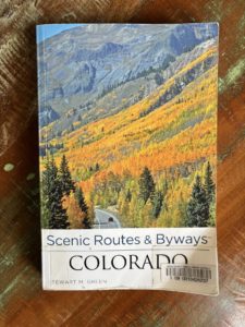
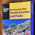
Scenic Routes & Byways Colorado by Stewart M. Green from the Palisade Library
Divide Road and Unaweep Canyon Experience
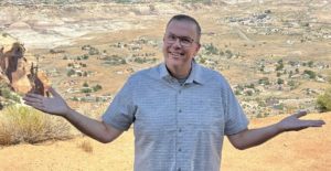
Guest post written by Michelle Aspelin, Grand Junction resident
I’m excited to tell you about our Divide Road and Unaweep Canyon experience. It was very cool, like a treasure hunt for us. A great idea on a long list of things to do in Grand Junction and the surrounding area.
I like to read books about Colorado. I check them out from the Mesa County Libraries or buy them from the Friends of the Mesa County Libraries book sales. I have purchased a few from our local Barnes & Noble too. A lot of what we do in Grand Junction is because I read about it in a book and want to see it in person.
Get notifications about new posts and watch Paul’s short videos on our Facebook page called Live Your Vacation in Grand Junction.
Divide Road on the Uncompahgre Plateau Inspiration
One of the books I discovered while browsing through the Mesa County Library in Palisade is called Scenic Routes & Byways Colorado by Stewart M. Green. It’s so good I may purchase it. My version is from 2013 and there’s an updated version.
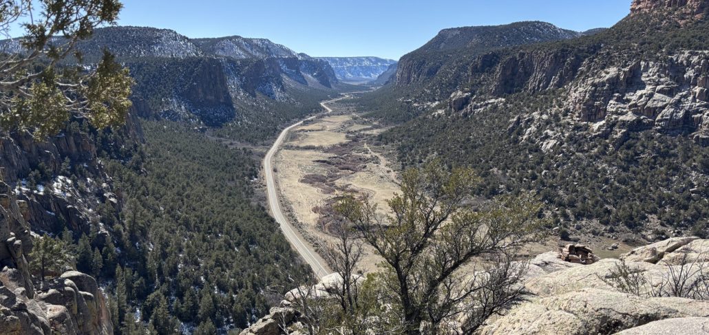
In the section about Unaweep Canyon the author talks about Divide Road. I have seen it on maps before and am aware of where it is on the high plateau. But when I read this passage, I said, “Let’s go!” Unaweep Canyon is supposedly the only canyon in the world drained by two creeks. A divide in the mid-canyon separates the East Creek and West Creek drainages. The Ute Indian name Unaweep means “Canyon with Two Mouths.”
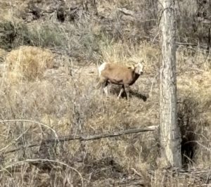
Big Horn Sheep on CR-141
To get there, drive south out of Grand Junction on Hwy 50. In Whitewater, turn right onto CR-141 towards Gateway. Go about 25 minutes and turn left onto Divide Road, it’s well marked. CR-141 is a beautiful drive through the Unaweep Canyon. We saw bighorn sheep along the side of the road before we turned onto Divide Road.
If you get a chance, drive all the way to Gateway near the Utah border. You will see some of the most incredible 2-billion-year-old granite walls and lush green valleys. Just beyond Divide Road, you can stop in a small parking area to see rock climbers on the 500’ steel grey cliffs of Mothers Buttress, Television Wall, and Quarry Wall. We saw people stopped with binoculars watching climbers on the sheer cliff walls. The land they climb is owned by The Access Fund, a national advocacy organization that leads and inspires the climbing community. Along CR-141 is some of the most impressive granite we’ve seen since the Black Canyon of the Gunnison National Park.
Here’s the passage in the book that inspired us to go there in March.
“Divide Road begins just past a ranch. This gravel road twists more than 100 miles down the spine of the Uncompahgre Plateau, giving access to a vast swath of remote backcountry. Take a left turn here for a short drive up Divide Road to a stunning viewpoint above Unaweep Canyon. The gravel road climbs a couple of miles up to the site of the abandoned Taylor Granite Quarry, a rock quarry that operated in 1928. Park before a cattle guard and walk down to the cliff edge for one of western Colorado’s most spectacular overlooks, Unaweep Canyon stretches westward. The highway below uncoils like a long snake up the sagebrush valley floor. Gentle slopes, forested with scrub oak, pinon pine, and juniper, slant upward to abrupt, towering granite cliffs. Above, steep slopes lean back to the valley’s sandstone rim high above the floor.”
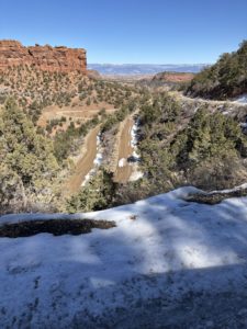
Switchbacks on Divide Road near CR-141
We left about 11am and packed our hiking backpack with hats, gloves, snacks, water, and the bear spray, you never know.
Divide Road is beautiful, lots of switchbacks and elevation gain right away. There was some recent snow still on the road in some parts. Other parts were muddy or dry gravel. We are used to driving in snow being from Minnesota, but when the road is narrow, and you look down over 1000’ feet with no guard rail, it can be a bit intimidating! We went slow. See the photo.
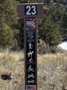
I read the passage again once we were past the steep part. We saw the cattle guard and a little parking lot off to the left at the trailhead of BLM Trail #23. We thought, “That could be it.” We weren’t sure and decided to go further on Divide Road. We got to a spot with a lot more snow and decided to turn around. We headed back to the first spot to see if that was it. This area is called Cactus Park in the Dominguez-Escalante National Conservation Area.
We later learned that the last icon on the post that looks like a jeep or ranger is actually for full size vehicles. Now we know!
There was another 4×4 truck in the tiny lot. We ate a quick snack. We weren’t sure how to read the signpost (see right) that marked the trail, wondering if we could drive it or if it was only for motorized bikes and UTVs, so we walked. I hadn’t looked up the trail before we left so we weren’t sure how far we had to walk to find the overlook. The book didn’t mention a BLM trail, but this was right next to the cattle guard. After about a half mile uphill all the way, we came to an opening and walked to the edge. We saw spectacular views of the Grand Mesa, West Elk Mountains, and the San Juan Mountains. It was amazing! Definitely a great view of western Colorado!
After that, we turned around to walk back and realized we were walking on the granite of the Taylor Granite Quarry! That was cool too. We had never been right on top of a quarry like that, they skimmed the surface, it wasn’t a big hole. We took more pictures.
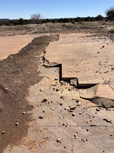
Taylor Granite Quarry
But the book said the view would be of the Unaweep Canyon. We realized this wasn’t it. Just then, a guy on a dirt bike stopped for a break near us. We explained what we were looking for and determined that the place we wanted to go might be further up Divide Road. He told us about another cattle guard and a road that veered right to a popular overlook. Since we had already gone further on Divide Road and saw the snow, we said we’d have to come back in April or May and try again.
The biker shared that there are a lot of elk in the area, trophy bull elk. We heard something in the thickets while on the trail, but we think it was just a mule deer. We never saw it. He said there are bears in the area, but they are small and they leave you alone. Ha! Small but they leave you alone. We had our spray just in case. We’ve never encountered a bear in Colorado. There are several BLM campsites along Trail 23. Camping on BLM land is free. We got in the truck and headed back.
Still wondering where the overlook was, we passed over the first cattle guard again and right next to it was a small pull-off we hadn’t noticed before. We could see the canyon in the distance. Maybe this was it? We parked and got out of the Tacoma. Sure enough, we walked about 50 feet over rocks and sand, past bushes, to the opening and boy, it was stunning! Huge drop-off beyond the boulder outcroppings. We walked up to the edge, like the book said, near the fence of the property owner. We were giddy. We found it!
We looked out onto the ledge, and someone had built a fire ring from stones in the area at the very edge of the overlook. You can see it in the photo below. What a way to watch the sun set over the canyon.
We soaked it all in, took more pictures and said, “We need to put this one on ‘the list’ and bring our guests here.” It was so amazing and only about 30 miles from our place. Yet being in the wilderness like that, up so high, we felt like we were in another world. So thankful to see it.
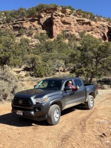
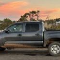
Paul Aspelin in the Tacoma at the Unaweep Canyon Overlook
We had such a good time on our hike and happy we found the overlook. When we got back into GJ we went to REI to get a book on the Dominguez-Escalante National Conservation Area. This would be a very cool place to rent an ATV and go four-wheeling, and maybe camp in the future. They didn’t have a book or map with that much detail about each of the BLM trails.
Later, after we got the mud washed off the taco (what the locals call a Toyota Tacoma), I looked it up online and was able to print out an 11”x17” map of the conservation area trail system, see below. We will definitely go back. Going in March was great, no bugs, but a bit of snow. The guy at REI didn’t know the road we were on was open again after winter. Oops, we didn’t realize it ever closed. Always learning!
We left with great memories, photos and stories of our experience, and the desire to explore more. If you are looking for things to do in Grand Junction, we highly recommend Divide Road and Unaweep Canyon. There are many pull-offs along Hwy 141 to stop and take in the beauty.
See Paul’s posts about our trip to Crawford State Park and the North Rim of the Black Canyon of the Gunnison National Park. We did both of those as one day trip from Grand Junction. Top Day Trips from Grand Junction is another great post.
Guest post written by Michelle Aspelin
© 2025 Paul Aspelin, REALTOR®. MovetoGrandJunction.com and Michelle Aspelin Copyright protected. All rights reserved.
Dominguez Canyon Wilderness BLM Map
![]()